

|
|
|
|
 |
||
A fine example of the Third Reich Conti Atlas für Kraftfahrer Deutschland mit Reichsautobahnen, a hardcover map book for motorists of Nazi Germany with 52 fold-out color maps and 140 city maps. |
||

|
||
A 6-language 1938 DDAC Strassenzustandskarte von Deutschland, a fine detailed color map showing the expanding road network of Nazi Germany. Looks unused. |
||
 |
||
Schlag nach über den Nahen Osten, a 42-page publication and matching color map of the Near East published for the Oberkommando der Wehrmacht (OKW) in 1941. |
||
 |
||
Schlag nach über den Sowjetunion, Die Ukraine und das Baltenland, 1941 publications about the Soviet Union, Ukraine and the Baltic countries published for the Oberkommando der Wehrmacht (OKW) with a color map of the Soviet Union. |
||

|
||
** SOLD ** |
||

|
||
The multilingual summer 1939 DDAC Strassenzustandskarte von Deutschland, a fine detailed color Nazi map showing the expanding road network and country of Greater Germany. |
||

|
||
An original 1935 Shell color map of the Mosel river from Trier to Koblenz ("Wine Country") designed by famous Professor Werner Peiner. |
||

|
||
A rare set of two 1942 dated color maps of the Mittelmeerraum, the area around the Mediterranean Sea published by the Central Publishing House of the Nazi Party as a special edition of the weekly newspaper Die Post. |
||

|
||
A 1939 DDAC Strassenzustandkarte des deutschen Alpenlandes, a very detailed color map of the German Alps and Austria for members of the DDAC, the AAA of Nazi Germany. |
||

|
||
An original 1941 "for Wehrmacht use only OKW color map of colonial Africa showing North Africa including Tripolitania, as well as southern Europe, British and French mandates in the Middle East, Saudi Arabia, Iran, and Afghanistan. |
||

|
||
A rare 1940 Nazi color map produced to educate Hitler Youth members in a Kinderlandverschickung-Lager about the war in the Pacific, 28-1/2 x 34 inches. |
||

|
||
An original Third Reich 2-sided color map of Central Germany produced by the Aral Oil Company, B.V.-Aral Karte 6. |
||

|
||
** SOLD ** |
||
|
||
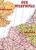
A colorful Nazi map showing the western borders Nazi Germany, with the Westwall and the Maginot Line as well as German colonies in Africa, produced by the Central Publishing House of the Nazi Party before the 1940 Wehrmacht invasion of western Europe. |
||

|
||
Deutsche Heimatkarte Blatt 2, a detailed map with tourist information of part of Munich, Bad Tölz, Bad Wiessee, Rosenheim, Wasserburg and including the SS Lebensborn Home at Steinhöring. Produced in 1938 in 1938 in cooperation with Ford of Köln, Agfa and the Leuna gasoline company of Berlin by Verlag Georg D.W. Callwey. |
||
|
||
** SOLD ** |
||

|
||
Multi-color map of München, Capital of the Nazi Movement, as sponsored by famous SA, SS, HJ and BdM uniform maker, Loden-Frey. |
||
 |
||
** SOLD ** |
||

|
||
** SOLD ** |
||

|
||
** SOLD ** |
||
 |
||
A rare 1933 Nazi car touring color map of Berlin and Brandenburg Province called Auto Touren-Karte Berlin und Umgebung mit praktischer Wegweiser. |
||
 |
||
Three original very detailed Nazi Postal District maps - historic parts of Hitler's expanded Greater Germany showing old and new borders. |
||

|
||
Large original Third Reich Grieben fold-out color map of
the north-German city of Hannover. |
||
 |
||
A large 22 x 28 inch, full-color Gau and Administrative District map of Adolf Hitler's Nazi Germany in 1940. |
||
 |
||
USA, Soviet Union, Poland and England. |
||